GIS & Web Development

The Web Development Team at First Base Solutions specializes in the creation of intuitive geospatial web based applications and streamlines access to a vast archive of data through our online sales tools and enterprise online services.  First Base Solutions has for over 20 years continually pushed the limits of web-based technology with the goal of delivering the most robust and user-friendly applications and services.

parcel banner

Web Development Applications

vumap logo

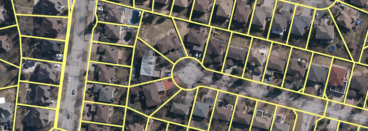
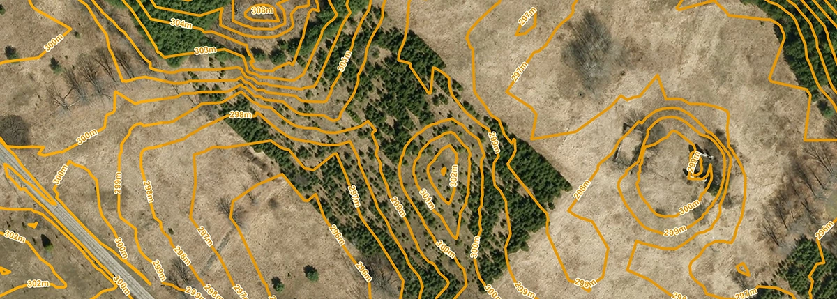
First Base Solutions launched VuMAP in 2005 and continues to support and update this application today. VuMAP is a browser based GIS (Geographic Information System) with geospatial data including roads, places of interest, elevations, high-resolution orthophotography, lot lines, right of ways, soil classifications and other data layers. Subscribers can measure distances, draw/trace objects, annotate, perform layer queries, save/print views, import and export data. VuMAP is used to locate and query real estate information. Property searches by address, intersection, township lot and concession, property identification number (PIN) and assessment roll number (ARN). Property information for reference; PIN, LRO Number, ARN, street name, street number, municipality, description and area of the property. Visualize slopes, industry, protected areas, watersheds, ecosystems, vegetation and soils in context with high-resolution orthophotography, property lines, right of ways, road allowances, easements and Google Street View. Historical property change detection.

mapcast logo

In 2009 First Base Solutions launched a web map service (image and tile services) for access to First Base Solutions’ orthophotography collection. The FBSWMS (First Base Solutions Web Map Service) provides user access to high-resolution orthophotography and contour information through the Internet. Any WMS compliant software can connect to the First Base Solutions database of imagery and contours and add it as a base data layer to the software for use in engineering and geospatial design projects. Users will have a highly detailed picture of the earth’s surface using current and accurate high-resolution orthophotography. Access via the WMS allows users to use First Base Solutions’ current and older imagery for historical record change detection. Our latest offering is MapCast which lets you access all of First base Solutions aerial imagery and elevation contours directly from your desktop CAD or GIS software. Use the aerial imagery base layer to help you plan, measure and add context to your existing vector maps. Research past and present site conditions at glance without the hassle of a site visit or paying for multiple data sets.

mapwarehouse logo

In 2001, we launched our first Ecommerce website, MapWarehouse http://maps.firstbasesolutions.com/, for imagery and geospatial data sales. The MapWarehouse on-line application allows users to purchase and download GIS data quickly using a simple Google Maps interface. The current datasets for sale on MapWarehouse include: digital orthophoto mapping, aerial imagery, Ontario parcel mapping, digital elevation models (DEMs), contours, Ontario Ministry of Natural Resources map products, 3D buildings, flood plain mapping and moraine groundwater subsurface geology. First Base Solutions’ current Ecommerce system is the front-end Ecommerce website (MapWarehouse) and the back-end administration website, a Content Management System (CMS). MapWarehouse has grown into a consistent and reliable revenue stream with the potential to grow well beyond its original function and is used by government, utilities, engineering, surveying, land development, environmental, planning, consultants and real estate clients.